Database Logic(s) and Landscape Art
Brett Stalbaum, C5 corporation
Surveyor: Precession of models and landscape [2/5]
The participation of the landscape in human culture is increasingly
understood through Global Information Systems. For example, the emerging
discipline of archeological geophysics uses GIS data to explore the
influence of geology on human political and economic history. [7] But the
operational inversion of this statement is also true: political and
economic history inflects (and often inflicts) itself on the landscape.
For example geologists and civil engineers enlist geo-data to help
physically reorganize the landscape; construction, mining, oil drilling,
landfill, agriculture, railroads, urban planning, waterworks, dams and
transportation are all endeavors that now prehend the landscape through
the use of geo-data. The landscape's own data is a player in the
systemization of our decision making. [8] Global information systems,
including the C5 Landscape Database [9] and related tools, demonstrate
precession of the model through processing data via semantically stable
data models, over which processing yields information that allows the
revelation of knowledge about the landscape which predicts our relation
toward it.
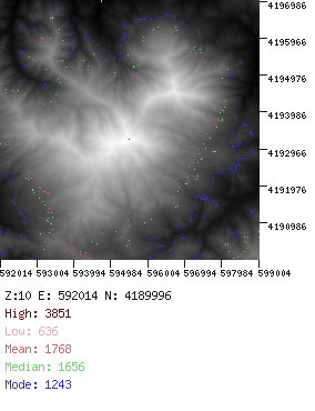
[image: Map of Mt. Diablo, California, UTM imager module, C5 Landscape
database (2002)]
(http://www.c5corp.com/raw_images/diablo.gif)
The practical outcomes of this knowledge indicate that the landscape
prehends to some degree its own modification by humanity. This concept
seems counter-intuitive, but an example makes it straightforward. Dams,
for example will be constructed in topographies and geologies that allow
them to function as dams. [10] Data models lie in some position between a
two way conversation between the cultural and the topographical that lead
to actual modifications of the landscape. In autopoietic terms, the
exploration of relations between topography and culture through
informational interchange is beginning to reveal examples of structural
coupling-like [11] behavior between them. To grasp this, it is important
to understand that data has simultaneously become a catalyzing factor in
the conversation, not merely an analytical tool for exploitation. This
feedback loop alters the character of the human relationship to landscape
from that of relatively unplanned domination to a somewhat more sensitive
symbiosis. [12] Data and control systems provide a channel through which
eco-systems are able to express an influence in favor of their own
protection. [13] In addition, the landscape occasionally demands (or
acquiesces to) a new bridge, water diversion, nuclear waste site or
freeway interchange. Thus one of the problems that artists (and possibly
scientists) working with landscape as data must deal with is the
embeddedness of the precession of models in-between the political and the
immanence of data as it is processed into information. This political
dimension to the inquiry deals with mapping as a cultural production
embedded within a set of scientific descriptors which drive our cultural
relationship with the land. How can we begin to describe the complexities
that emerge from this relationship?
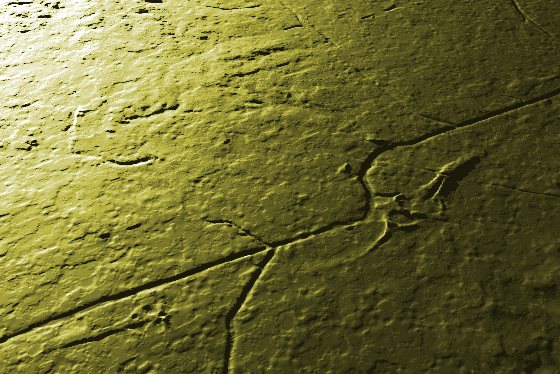
[image: Evidence of the cultural in landscape data, Memphis, TN.]
(http://www.c5corp.com/raw_images/MEMP1.gif)
Data, which is non-controversially real in an ontological sense, is now a
formative influence on the actualization of the landscape through
virtualization in information technology systems. The notion of virtual in
this description is drawn from Deleuze's schema for describing
multiplicities, as discussed by Delanda. [14] It does not refer to the
interfacial notion of 'virtual reality', but rather to the actualization
of reality through velocity vector fields (or tendencies to behave) that
manifest themselves as actual (measurable) trajectories of physical
systems as expressed in relational constraints between its vectors. The
trajectories resulting from relative constraints tend to settle into
consistent patterns of interaction with one another. Observations of
velocity vectors and trajectories in actual systems allow phase portraits
describing such systems to be embedded in simulated manifolds consisting
of descriptors of the vectors and their trajectories. The phase portrait
simply describes the interactions inherent in the actual system. Applied
science utilizes this schema to model physical systems; analyzing behavior
through repeated observations of actual physical systems, and then using
computer models developed through the informatization of such observations
into manifolds to animate vector descriptors into phase portraits. Through
simulated manipulation of descriptors describing velocity vectors,
scientists are able to model natural systems and predict complex behavior.
The United States, for example, has ceased to physically test nuclear
weapons, because these can be tested virtually with super-computer
simulations.
For Delanda and before him Deleuze, virtuality is not merely a
contemporary artifact of computation, but rather identifies the proximity
of concrete attractors, realities which attract the actualization of
systems, and which for Delanda replaces essences in philosophy. It is
specifically because the virtual is real (or more real than real) that it
can be explored computationally, where for example Plato's ideal forms
simply can not be computed. In other words, virtuality implies a
relationship to the actualization of systems in concrete terms, not
transcendental terms. The concreteness of attractors are demonstrated in
"various long term tendencies of a system… which are recurrent
topological features, which means that different sets of equations,
representing quite different physical systems, may possess a similar
distribution of attractors and hence, similar long-term behavior." [15] In
more common Deleuzeian terms, attractors are abstract machines: general
abstract processes (such as stratification, meshworks, blind replicators)
that play an embedded role in the instantiation of a concrete actual.
Simulations really help us study actual systems, including geology,
watershed, landcover, and topography. Thus the virtual is defined in terms
of attractors or actuators of the real, not the imaginary virtual reality
worlds that have been the subject of so many art projects.
Data is thus not unreal; it is a virtual reality that participates in
instantiation. The mechanisms of data that participate in actualization
can be discovered through modes of experimental exploration in virtual
space. We might be tempted to infer that it is the information, knowledge,
(and related opportunity) that can be mined from modeled data (in relation
to the virtual), which play the catalytic role in the generation of the
real landscape where humanity is involved, and to a large degree, this has
been the case historically. In this view, the techniques of virtual
science allow us to search for predictive scientific truths that can be
rationally manipulated. But of course, there are perspectives that
potentially make this inference problematic. We could, for example, pose a
Marxist-semiotic analysis; positing that there exists parasitic cultural
assumptions that cleave to (or are expressed in) data models (and thus the
data collected), which are otherwise sincerely generated for scientific
purposes. In other words, do notions of progress, development, land use,
extraction of natural resources and other cultural or economic desires
dictate the manifold, perhaps through omission of descriptors, based on
the 'purpose' that the data is intentionally collected for? This could
explain the subtle and perhaps even unintentional manipulation of science
to either deny or confirm humanity's influence on global warming, to site
just one well known example.
Alternatively, data's role in the instantiation of the actual may be a
matter of virtual informatic interrelations (or external relations between
data sets), forming their own consensual domains [16] that heretofore have
not yet been observed as such, but which potentially inflect the operation
of actual systems via informational transfer between neighboring systems
of interrelations. In other words, data interrelations may themselves be
vectors that influence the trajectory of actual systems. This theory
depends on the idea that data is not only real, but actual, and capable of
actualization. Although it is likely that all of these issues are all
interoperable to some degree, Joel Slayton hints at C5's orientation by
posing the following: "These are factors of economic and political
assessment which infer that database logic necessarily has to surpass…
intentionalities. Are artists just going to do economic, rainfall and
surveillance models, or does the question shift to other subject-less
concerns of mere informatic relations? If so, what is the semiotic
context?" [17] Subject-less (or non-semantic) informatic relations must
express some form of semiotic-like behavior if actual (because actual
systems can ultimately be signified, such as imaginary numbers), but would
be difficult to penetrate from either the examination of their semiosis,
(how do we observe a system when we don't know what questions to ask), and
from the perspective of a language to express that which is after all
non-semantic. "Clarity endlessly plunges into obscurity" [18] under such
analytical circumstances. This is obviously a highly speculative
territory, but if tactics to reveal such relations of data can be
developed, and if they can be generalized, then we have a new
understanding of database [19] that may account for the two way
conversation between the cultural and the topographical, (or the genetic,
the chemical, the quantum, etc.) C5 enters this terrain in explorative
fashion though the semiotic context of our discipline (as artists), with
landscape and its data as the object of study.
[next installment: Mountainous: Semiotics, and the precession of semantic
models]
[7] For a good example, see http://fisher.lib.virginia.edu/projects/salem/
The GIS of "Salem Village in 1692" is part of an electronic Research
Archive of primary source materials related to the Salem witch trials of
1692.
[8] This is one aspect of C5's research into geo-data and technology in
the landscape: allowing or encouraging alternative examples of potentially
healthy and interesting 'revelation' on the part of the landscape to be
fulfilled.
[9] http://spike.sjsu.edu/~gis (Alpha)
[10] This is even known to happen "naturally":
http://perso.wanadoo.fr/nyos/dam/hazard.htm
[11] Maturana, Humberto R., and Varela, Francisco J., The Tree of
Knowledge - The Biological Roots of Human Understanding, 1987 Shambhala
Publications, Boston Massachusetts. Pg 75. "[A] history of recurrent
interactions leading to the structural congruence between two (or more)
systems."
[12] For example, data plays a significant role in decision making in the
nascent movement to remove unneeded dams in the United States.
[13] A good example can be found in accomplishments of the Mono Lake
Committee founded by scientist David Gains in 1978, who used scientific
data as the basis of the Committee's work to save the lake. It was the
data that convinced the justice system that the lake needed to be better
managed.
[14] Delanda, Manuel Intensive Science & Virtual Philosophy, Continuum,
370 Lexington Ave, NY NY 2002, pg 36
[15] ibid 15
[16] Wittig, Geri, Expansive Order: Situated and Distributed Knowledge
Production in Network Space,
http://www.c5corp.com/research/situated_distributed.shtml
[17] Quoted from a personal conversation, with permission.
[18] Slayton, Joel and Wittig, Geri Ontology of Organization as System,
Switch - the new media journal of the CADRE digital media laboratory, Fall
1999, Vol 5 Num 3, http://switch.sjsu.edu/web/v5n3/F-1.html
[19] Stalbaum. Brett, Toward Autopoietic Database, a research paper for
C5. (2001) http://www.c5corp.com/research/autopoieticdatabase.shtml
Database Logic(s) and Landscape Art [2/5]
-
Type: discussion