[img]http://lh4.ggpht.com/_DBhn2KFYbgc/SpxVUXCG6_I/AAAAAAAAfqs/W1WKg80zuB0/s288/WS000001.JPG[/img]
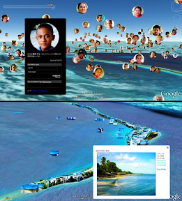
”Tuvalu Visualization Project” is an art project visualizing information of Tuvalu on Google Earth. This project is composed of two elements.
1. Visualization and communication system for NPO Tuvalu Overview's ”Build the Future with 10,000 Tuvaluans”
2. ”Tuvalu Mapping” constructed with 3300 GPS photographs of Tuvalu
The purpose of project is to disclose actual information about ”People” and ”Scenery” in Tuvalu to the world.
It is said that Tuvalu is exposed to danger of going under water by sea level rising because of global warming. However, we suppose that it is important to understand not only the problem of global warming, but also the real situation of Tuvalu. The Internet is an effective tool for collecting information, but it was difficult to obtain information of the real situation of Tuvalu from the Internet.
Therefore, we produced this project to present the real situation of Tuvalu, to improve the interest in Tuvalu, and to receive feedback from all over the world. The complete version of this project will be published to the web on the end of Sep.2009. (Hidenori Watanave)
Tuvalu Visualization Project
NPO Tuvalu Overview,
Hidenori Watanave Laboratory@Tokyo Metropolitan University
(Hidenori Watanave, Makiko Suzuki, Yuichi Watanabe)
Supported by Photon,Inc.
Tuvalu Visualization Project Preview
-
Type: event
- Location: JP
- Starts: Sep 1 2009 at 12:00AM
- outbound link ↱