Hidenori Watanave Laboratory of Tokyo Metropolitan University created
two mash-up contents for visualizing the damage situation of the Japan Earthquake using Google Earth.
1. 3D photo-overlays from "The Aftermath in Japan" by New York Times
[img]https://lh3.googleusercontent.com/_DBhn2KFYbgc/TYyww-xP1II/AAAAAAAA6XI/SLzxjLcUINA/s400/%E8%A2%AB%E7%81%BD%E5%9C%B0%E3%83%9E%E3%83%83%E3%83%94%E3%83%B3%E3%82%B0.jpg[/img]
Users can view 40 photographs from "The Aftermath in Japan" by New York Times using google earth, and compare sceneries before / after the earthquake. All photographs are overlapped with three-dimensional geographical features. The damage situation of the Sendai airport and the Fukushima nuclear power plant and others can be understood three-dimensionally. And also, Google's imagery update of Japan is included, users can switch latest and past satellite image by radio-buttons. We will add more photographs as much as possible. >> http://shinsai.mapping.jp/photooverlays.html
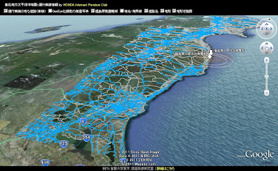
2. Traffic results information mashup from HONDA & TOYOTA
[img]https://lh4.googleusercontent.com/-Y0E0s90lZkY/TX4BjkBfS-I/AAAAAAAA5dc/kEC4CvW7NCo/s400/WS000001.JPG[/img]
The traffic results information of the area of devastation of the
Japan Earthquake (daily update) by HONDA and TOYOTA are overlapped with other geographical data. Available roads and other information are overlapped, so users can understand the real situation of the area of devastation easily. Two or more layers can be switching with check boxes. Please wait for a while until contents are displayed because the data size is large. We can mash-up other layers. If you have some requests, please contact us. >> http://shinsai.mapping.jp/
Hidenori Watanave
Associate Professor
Graduate School of System Design, Tokyo Metropolitan University
[email protected]
Visualizing the damage situation of the Japan Earthquake
-
Type: event
- Location: JP
- Starts: Apr 3 2011 at 9:02AM
- outbound link ↱