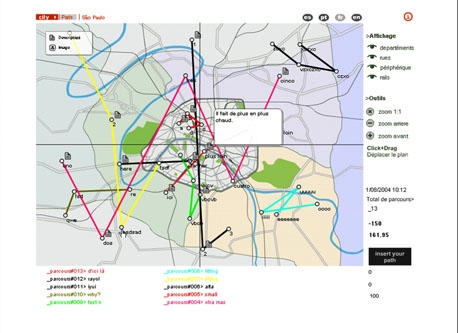
"A Map Larger Than the Territory" is a Web application that enables participants to represent their paths across the city using images, texts and sounds. Territory here is not a piece of land enclosed within borders but an interlocking network of lines or ways through. The map materialises and connects individual trajectories.
Full Description
"A Map Larger Than the Territory" is a Web application that enables participants to represent their paths across the city using images, texts and sounds. Territory here is not a piece of land enclosed within borders but an interlocking network of lines or ways through. The map materialises and connects individual trajectories.
How does it work? Choose a city and a language. The map shows other people's paths in that city. A button at the right sends you to a blind map where you can add an itinerary of your own. To do so, you must first give it a name, a date and a color. Use the tools provided to locate places on the map and define points on your path. Each time you mark a location, a dialog box opens up for you to identify and describe it. When you have finished marking up your path, you can view the itinerary you have made.
Scenario: Karen O'Rourke Programming: Cesar Restrepo
Work metadata
- Year Created: 2004
- Submitted to ArtBase: Sunday Feb 10th, 2013
- Original Url: http://www.mapterritory.com/
-
Work Credits:
- korourke, primary creator
- Cesar Restrepo, programmer
Take full advantage of the ArtBase by Becoming a Member
Artist Statement
The project began in 2001 with a series of events and web projects. http://korourke.pagesperso-orange.fr/map/index.en.html
Australian aborigines find their way in unfamiliar country without using navigational instruments or notions of astronomy. They construct cognitive maps based on myths, traditional songs and stories, which describe in general terms the physical features of their ancestors' Dreamtime tracks, camps and sacred sites. Their very precise geographical knowledge comes above all from wayside conversations with other travelers who delight in describing in great detail the places they know, either from firsthand experience or from hearsay.
A far cry from Breton's experimental wanderings or Baudelaire's "flâneries", our own daily itineraries would appear at first to be rather well-beaten trails, limited in scope. Their very banality would seem to automatically exclude any discovery or chance encounter. In the métro at rush hour don't we sometimes feel we've seen those same faces so often they have become landmarks? At least we're not on the wrong platform… By asking participants to recount their paths across the city, this project aims to build experiential maps based on such notions as landmark, district, edge or boundary, path, rendezvous. What details reveal a neighborhood, an intersection, a street? What characteristics of places or routes help us to find our way in a complex urban center? What information is charted on our mental maps? What makes them specific to Paris, London or Tokyo?
Many of our waking moments are devoted to getting from one place to another. Although we often feel this is time wasted, like negative space in a graphic design, it models the "positive" moments in surprising ways. However mundane, each of our urban itineraries tells a unique story. Why this particular trip today? How did we find our way? Which path, which means of transportation did we choose? What was the weather like? What did we see, hear, smell on the way? What remains afterwards? Our itineraries reveal not only our personal choices or tastes but also cultural and political determinations. The hundred kilometer trip from Jenin to Hebron on the West Bank could take either two hours or fourteen, depending on whether we are required to stop at the 24 army checkpoints on the way . To a greater or lesser degree, our travel vicissitudes point to larger issues, providing clues about living conditions in a given time and place.
Guy Debord defined the dérive [literally: “drifting”] as “a technique of rapid passage through varied ambiances. Dérives involve playful-constructive behavior and awareness of psychogeographical effects, and are thus quite different from the classic notions of journey or stroll.” Geography “deals with the determinant action of general natural forces, such as soil composition or climatic conditions, on the economic structures of a society, and thus on the corresponding conception that such a society can have of the world. Psychogeography could set for itself the study of the precise laws and specific effects of the geographical environment, consciously organized or not, on the emotions and behavior of individuals.” The Situationists looked out for the subliminal messages in urban planning, for them psychogeography was a sort of city-space cut-up. They developed specific techniques for objectifying their “dérives”, such as navigating in Paris using a map of London. Today members of the Utrecht-based group “Social Fiction” have developed algorithms derived from Conway’s “Game of Life” to determine their itineraries. “Generative psychogeography, strolls following a route generated by an algorithm, has been developed to test the proposition that once you start using the city in a different way you will find out that there are a myriad of discoveries possible.”( Wilfried Hou Je Bek).
A Map Larger than the Territory develops a Web application that will enable participants to represent their urban travels online, using images, texts and sounds. The result will be a kind of "Map of Tender" charted by surveillance technology. Each trip can be analysed and/or simply recounted. The five minute walk to school could be structured like Lévi-Strauss’s Tristes Tropiques, a shopping expedition to the Printemps department store could mean advancing into the “Heart of Darkness" of the January White Sales.
The project involves:
- A Web-based method of notation for participants to recreate and visualize their itineraries online, using both text and image files they have uploaded and information available from the database and on the Internet.
- A searchable, modifiable online database of participants’ urban itineraries made up of information gathered online and links to other material. At present the database contains textual descriptions culled from responses to an online questionnaire. It aims to restitute the variety and complexity of the narratives, allowing readers to draw meaningful parallels. In order to consult it, one is asked to contribute an itinerary.
- A rescalable, zoomable map interface that allows one to view all the itineraries on file. The mapped relationships will be semantic, topographic rather than strictly geographic.
- An online Rummage Sale for used itineraries, a networked Market where users can preview, download, buy, sell and exchange copyrighted, copylefted or trademarked itineraries.
The database intentionally confronts descriptions of very different itineraries, adults driving to work and children running off to play, well-worn commutes and spontaneous joy rides, quick jogs over to the corner drug store and slow traffic crossing town, early-morning dog-walks and late-night bar hops, each capable of revealing a specific aspect of our urban imaginary. The infinitesimal details of our subjective itineraries, which on their own might seem trivial or anecdotic, take on significance when confronted with others, many others. In conjunction with a great quantity of other details, unique stories and ordinary trips, they form a new entity, a dynamic whole which is greater, more intelligent than the sum of its parts.
The Map with its marketplace of itineraries and network of links holds up a mirror to the city. The more a city favors diversity, the more lively it is. Versatile, multifarious, abundant, it is a dynamic system that results largely from simple interactions between its inhabitants and their living spaces . Acting individually, interacting with others at a local level, they produce complex, collective behavior at a higher, global level. The Map, like the city as a whole, forms an organized complex system made of “situations in which a half-dozen or even several dozen quantities are all varying simultaneously in subtly interconnected ways". Rather than creating an object for contemplation , this project focuses on the interconnections, the ways in which data networks “work”.
See my articles: « A Map Larger than the Territory », ICHIM 04, Berlin, Proceedings. September 2004. « [Mapping the Database] »(with S. Daniel), Leonardo, Volume 37, Issue 4 (August 2004) "Une carte plus grande que le territoire", Livraison N°4, Rhinocéros, Strasbourg, 2004. « Trajectoires et perspectives des bases de données: la représentation en ligne de l'expérience spatio-temporelle » (with S. Daniel), Actes du colloque Artmedia 8, Ligeia, Paris, « Bases de données : Trajectoires et perspectives » (with S. Daniel), Plastik N° 3, automne 2003, CERAP/Université Paris 1, Paris, Publications de la Sorbonne, 169-176.
Books which reference this work: Fred Forest, Art et Internet, Paris, Editions Cercle d'art, 2008, 116-119. Stephen Wilson, Art + Science: How scientific research and technological innovation are becoming key to 21st-century aesthetics London/Paris: Thames and Hudson, 2010, pp.182, 186.
Related works


