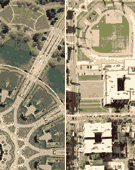
This interactive atlas is driven by a basic php script that loads two images upon each visit. The foreground features a location somewhere in the District of Columbia and the background features a location some other place in America.
Each time the visitor clicks on the foreground image, a new foreground & background image is reloaded. The foreground folder contains 266 modifed aerial photographs (both close-ups & tessellations) from every previous District of Columbia work made up until 2006. The background folder contains 145 aerial tessellations of urban areas throughout the United States derived from each of the works I made in 2006.
The atlas is click-driven net art that features a juxtaposition of America & the District of Columbia that is both an abstract geovisual representation of urban America and a critique on the lack of electoral representation in the District of Columbia. Without a formal voice in the ...
Full Description
This interactive atlas is driven by a basic php script that loads two images upon each visit. The foreground features a location somewhere in the District of Columbia and the background features a location some other place in America.
Each time the visitor clicks on the foreground image, a new foreground & background image is reloaded. The foreground folder contains 266 modifed aerial photographs (both close-ups & tessellations) from every previous District of Columbia work made up until 2006. The background folder contains 145 aerial tessellations of urban areas throughout the United States derived from each of the works I made in 2006.
The atlas is click-driven net art that features a juxtaposition of America & the District of Columbia that is both an abstract geovisual representation of urban America and a critique on the lack of electoral representation in the District of Columbia. Without a formal voice in the House or Senate in the United States Congress, the residents of the District of Columbia are technically colonists living under the tyranny of those in living in the background. By random selection, its nearly impossible to identify the locations featured in each viewing of the atlas, but the inequality of representation remains present; in size, location, number, and even the color of the original aerial photographs.
America is the last industrialized nation to have a colony as it's capital city and while this atlas might not help you find out why this faux-pas of America's Founding Fathers still exists, it offers a way to get lost in America's Last Colony.
266 times 145 = 38,570 potential combinations, or 38,570 ways to get Lost in America’s Last Colony.
This on-line atlas was originally published on my website on March 10th, 2007.
Work metadata
- Year Created: 2009
- Submitted to ArtBase: Monday Mar 30th, 2009
- Original Url: http://nikolasschiller.com/lost/colony.html
- Permalink: http://nikolasschiller.com/lost/colony.html
-
Work Credits:
- Nikolas Schiller, creator
Take full advantage of the ArtBase by Becoming a Member


