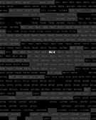
This piece consists of a complete listing of Manhattan property, indexed by block/lot. Blocks are indicated through an alternating dark-gray background. Vacant lots are invisible until moused-over, in which case the visual hierarchy is inverted and they become visible, while the other lots disappear. Clicking on any listing will open a window with corresponding geographic information from the New York City Open Accessible Space Information System Cooperative (OASIS), a partnership of over 30 public and private organizations. The source of the index is data compiled by the New York City Department of City Planning.
There are two underlying issues which Property Codes seeks to address. The first is the notion of context and image. How does geographic context and our perception of place change through cross-referencing it with an indexical profile of tax lots, the foundation for the classification of property? Does their side-by-side comparison give us any more insight into the why and how behind the form of the city?
The second issue is the comparison between the program and it’s compilation. Both views—geographic and indexical—are compiled from similar underlying source data, yet their forms of representation are inherently different. Linking the two compiled states raises the question of program, as well as the source: by mediating one view through the other, as is the case here, the implicit assumption is that the data is shared and matches in both cases. Yet, as one quickly discovers through discrepancies in the two data-sets, this is clearly not the case. Ultimately, these discrepancies become a means for understanding passage of time and the dynamics underlying both the data and the city.
Full Description
This piece consists of a complete listing of Manhattan property, indexed by block/lot. Blocks are indicated through an alternating dark-gray background. Vacant lots are invisible until moused-over, in which case the visual hierarchy is inverted and they become visible, while the other lots disappear. Clicking on any listing will open a window with corresponding geographic information from the New York City Open Accessible Space Information System Cooperative (OASIS), a partnership of over 30 public and private organizations. The source of the index is data compiled by the New York City Department of City Planning.
There are two underlying issues which Property Codes seeks to address. The first is the notion of context and image. How does geographic context and our perception of place change through cross-referencing it with an indexical profile of tax lots, the foundation for the classification of property? Does their side-by-side comparison give us any more insight into the why and how behind the form of the city?
The second issue is the comparison between the program and it’s compilation. Both views—geographic and indexical—are compiled from similar underlying source data, yet their forms of representation are inherently different. Linking the two compiled states raises the question of program, as well as the source: by mediating one view through the other, as is the case here, the implicit assumption is that the data is shared and matches in both cases. Yet, as one quickly discovers through discrepancies in the two data-sets, this is clearly not the case. Ultimately, these discrepancies become a means for understanding passage of time and the dynamics underlying both the data and the city.
Work metadata
- Year Created: 2007
- Submitted to ArtBase: Sunday May 20th, 2007
- Original Url: http://www.christianmarcschmidt.com/index.php?template=project&id=property_codes
- Permalink: http://www.christianmarcschmidt.com/index.php?template=project&id=property_codes
-
Work Credits:
- Christian Marc Schmidt, creator
Take full advantage of the ArtBase by Becoming a Member