We launced “eARthquake 311” - iPhone & iPad Apps of The East Japan Earthquake Archive.
[img]https://lh5.googleusercontent.com/-4LXvMV60rU8/Tt4TEtBsrzI/AAAAAAABFck/KaZi3_Y3H8o/s640/Desktop3.jpg[/img]
- Official Website:
http://e.nagasaki.mapping.jp/p/japan-earthquake.html#eARthquake311
“eARthquake 311” is an iPhone AR Apps version of a pluralistic digital archive - “The East Japan Earthquake Archive”. Download for free. For iPhone / iPad.
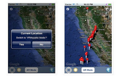
The Map Mode that displays data by using Maps. Data are displayed by touching markers. And more, in Japan, Users can know the situation caused by The East Japan Earthquake in March 11, 2011 using a GPS function.
By using “The AR (Augmented Reality) mode”, Data can be displayed by AR overlapping with actual cityscape. The user can know the distance between stricken areas and current location.
[img]https://lh5.googleusercontent.com/-OetDC40itCg/TuP28MVxCiI/AAAAAAABFlY/TG7Aw9yE06o/s400/WS000000.JPG[/img]
At places other than Japan, A user's present location can be set up as “VRthquake” place. So the scale of the damage caused by Earthquake can be understood by AR overlapping with user's own town.
“eARthquake 311” has a function of Twitter. The hashtag “#japan311” is attached to user's tweets. Communication between users is urged by this function.
Thank you very much,
–
Hidenori Watanave
Supervisor of Photon,Inc.
Associate professor,
Graduate School of System Design, Tokyo Metropolitan University
“eARthquake 311” - iPhone & iPad Apps of The East Japan Earthquake Archive
-
Type: discussion